The online noticeboard platform, which grew out of a Guardian hack day, gets a major update, including a tool that allows noticeboard owners to add an automated feed of geotagged tweets, Instagram photos and more
This article was migrated from an old version of our website in 2025. As a result, it might have some low-quality images or non-functioning links - if there's any issues you'd like to see fixed, get in touch with us at info@journalism.co.uk.
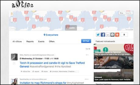
Online noticeboard n0tice , a project that grew out of a Guardian hack day, has had a major update , adding an Android app, updating its iPhone app and introducing a new location-based curation tool called FeedWax .
The website has also been updated, a campaign to "celebrate or change" high streets across the country has been launched, and this morning n0tice moved from Google Maps to open source platform Open Street Maps.
n0tice, which launched in private beta in May 2011 , allows anyone to set up and curate a noticeboard and offers the opportunity to earn money as the site is funded by location-based small ads.
It now has "thousands of active users who are creating their own noticeboards around a local area or a subject area of interest", Sarah Hartley community strategist for n0tice told Journalism.co.uk. Most noticeboards have been created around geographic areas, plus there are also some around subjects such as a vibrant craft noticeboard.
n0tice has also been used to provide news coverage . During flooding in Bridport, Dorset, the town was cut off and n0tice became "the news source for that town", Hartley said.
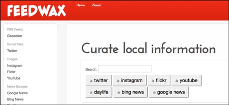
Automating location-based feeds
Those from local news outlets or community groups that have set up an online noticeboard on n0tice can now use new curation tool FeedWax to automatically add information to their board, including geotagged RSS feeds, tweets, Instagram and Flickr photos, YouTube videos and more.
For example, Hartley created this noticeboard on Felix Baumgartner's skydive to demonstrate how the tool can be used. She used the app to automatically add Instagram pictures tagged #livejump.
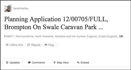
Hartley has also been testing the tool by using the RSS function to automatically post planning applications to the local board she manages . Hartley has added a geotagged RSS feed of planning applications taken from OpenlyLocal , an open data service which aims to make local government more transparent. For more on location-enabled feeds, or GeoRSS, see this blog post by Matt McAlister , who is also working on n0tice.
Hartley, who also works with community media project Talk About Local, has also been experimenting by linking a Talk About Local project on augmented reality with the planning application information. She has been "playing around" and now anyone who uses the augmented reality app and points their smartphone at one of the buildings subject to a planning application will see the information.
High street campaign
n0tice has also launched a campaign centred on mapping photographs of the UK's high streets. "We are inviting people to add things about their local high streets that they love and want to celebrate - but also things that they'd rather change," Hartley said.
n0tice, which is working with marketing company LBi for the campaign, aims to create "the UK's largest photographic infographic".
One of the aims of n0tice is to "celebrate a sense of place", Hartley said and "this high streets campaign has come out of that".
"It demonstrates a way in which technology can be used that may lead to action on ground".
A release from the Guardian adds that "subsequent campaigns will address cycling safety and supporting independent local shops".
Sarah Marshall is VP Audience Strategy at Condé Nast. She leads distribution and channel strategy globally. She is also the former technology editor for Journalism.co.uk (prior to it becoming JournalismUK)