Tool for journalists: Create interactives with Story Maps
Create different styles of maps to tell visual stories with this free resource
– 3 min read
Create different styles of maps to tell visual stories with this free resource
This article was migrated from an old version of our website in 2025. As a result, it might have some low-quality images or non-functioning links - if there's any issues you'd like to see fixed, get in touch with us at info@journalism.co.uk.
A tool for creating multimedia interactive maps
Use Story Maps to build embeddable maps to explain stories that happen across different locations and time periods.
The storytelling tool uses ArcGIS Online, a mapping platform from Esri , to create a variety of map styles which can be added to news stories to create a more engaging experience for readers.
Each map application is built with a different storytelling style in mind, with options ranging from linking geotagged photos to a map to juxtaposing two different maps to showcase differences over time. Story Map Tour and Story Map Journal can also be used to take readers on a journey following points on a map, connected in a particular order.
Other options include Shortlist , for creating a map of curated lists of interesting places which will then be organised through tabs; and Playlist , which previews all the points on a map by showing the top line of the story and a thumbnail of the featured photo. Story Map Series , currently in beta, also enables users to tell stories by building a series of maps presented within the same embeddable feature. This post on the Story Maps blog explains what types of stories would fit each style of map, and lists the web apps that are easiest to build and most popular.
For example, Mashable used Story Map Tour earlier this year to explain how IS took control of Iraq by mapping its movements through the country .
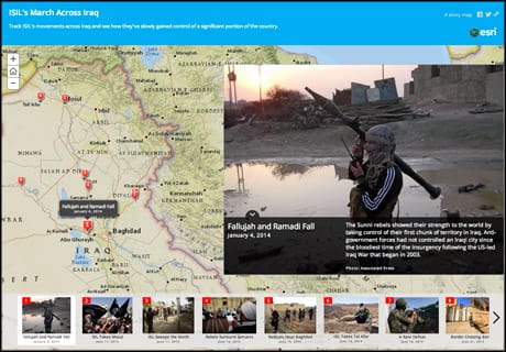
Screenshot from Mashable
You can create a Story Map for free with an Esri public account, but there are some limitations to what you can do with this type of access.
For instance, you need to upload your images and video to a third party website such as Flickr, Facebook or YouTube to create a Tour.
ArcGIS only allows ArcGIS Online subscribers to upload images straight to the Tour, although public users can upload data from a CSV file.
To import images from Flickr, you need to first find the account you need, and then pull in images from a selected photo set or a certain tag.
A YouTube import works in a similar way, requiring map builders to know the username of the account in advance as there are no social media search functions within the import feature.
Note as well that Story Map will only import up to 99 photos or videos from each source when using a public account.
ArcGIS has published a step-by-step guide to building each type of map, which can be found under the 'Tutorial' tab on the application's homepage.
Certain apps, such as Tour, Journal, and Basic also have an interactive map builder to help you create your visual story.
ArcGIS has also collected examples of where the maps have been used online, such the Ebola response roadmap situation report from WHO, and this interactive mapping Ebola outbreaks since 1976 published in October by the Guardian.
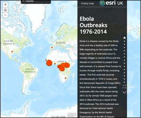
Screenshot of a Story Map Journal from the Guardian
There are also maps created by the ArcGIS team among the featured examples, like this Story Map Journal looking at the "death and the rebirth of malls" in the United States.
Once you are happy with the map, you can share it on Facebook, Twitter, link to it, or embed it into your story.