Crowdmapping Denmark's CCTV cameras
How a Danish new outlet is getting readers to use an app to map CCTV cameras

– 2 min read
How a Danish new outlet is getting readers to use an app to map CCTV cameras
This article was migrated from an old version of our website in 2025. As a result, it might have some low-quality images or non-functioning links - if there's any issues you'd like to see fixed, get in touch with us at info@journalism.co.uk.
Danish daily newspaper and online title Dagbladet Information is mapping the positions of surveillance cameras by encouraging readers to use a free Android and iPhone app to photograph and geolocate CCTV cameras.
The ' camera spotter ' crowdmapping data journalism project has been running for six months and is tied in with a series of features on surveillance published in the print edition over a two-month period.
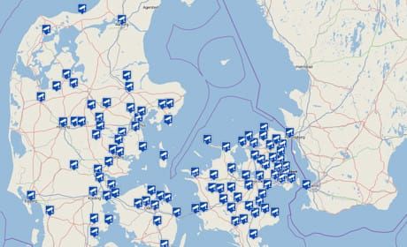
Since the apps were launched by Dagbladet Information in March, they have been downloaded 4,500 times and 2,200 CCTV cameras have been photographed by readers and verified by journalists.
Sebastian Gjerding, who is working on the project along with colleague Peter Anderson, told Journalism.co.uk that the 'watching the watchers' series of features came about due to a rise in the number of surveillance cameras in Denmark and debate around the retention of mobile phone data.
"Surveillance technology is growing for two reasons: cheaper technology, and also a fear of terror attacks is also a factor that is driving this," Gjerding said.
Gjerding added that using data journalism for the 'camera spotter' project ties in with the debate: gathering and making sense of data.
Gjerding said that the journalists asked themselves: "If we use the same method, what can we find out about the way they are gathering data and how widespread the surveillance is?"
In order to track the CCTV cameras Gjerding and colleagues realised they needed GPS, a camera and a map. "And those three things are of course already on the smartphone, so we were using the technology that's in everyone's pocket."
The print features provided a "boost" for the app, with 1,500 cameras mapped within the first month.
When someone maps a CCTV camera by submitting a photo they are asked to check if the position recorded by their smartphone's geolocation function is precise. "Normally it's only five or 10 metres out," Gjerding explained.
After the camera details are submitted, Gjerding is then tasked with verifying the images, which is in part done by using Google Street View.
The app also has a map function which allows app users to see the locations of the cameras mapped. "They are able to experience the surveillance city in another way," he added.
Gjerding said that the technology could be used in another country. For anyone interested in taking inspiration from Information's project, his email is at this link .